


Navigraph Charts

Beschreibung von Navigraph Charts
Are you into flight simulation? Navigraph Charts is the preferred charts app in the flight simulation community offering the largest coverage available of Jeppesen charts updated continuously every 28 days following the AIRAC cycle.
Navigraph Charts allows you to search, view and organize airport charts from 6,800 airports around the globe. You can connect it to FSX, Prepar3D or X-Plane, to plot your position on charts, or use it independently to plan your route.
Navigraph Charts contains the following features:
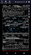
- Worldwide and current Jeppesen IFR charts: 6,800+ airports covered (requires Navigraph subscription)
- Moving maps: connect to X-Plane, FSX and Prepar3D to show the simulator's aircraft position on the charts in real time (requires Navigraph Simlink on simulator computer)
- Night mode: Dark theme version of the charts for low ambient light conditions
- Route calculation: Automatically calculate a route between any airport pair directly in the app
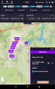
- SID and STAR visual overviews: View airport procedures overlaid on the enroute chart for better understanding of the airspace and more straightforward flight planning
- Flight organization: Interactively display the flight's route on the enroute chart, and collect charts for departure, destination and alternates in a single place
- Chart overlays: Overlay SID, STAR and approach charts on the enroute chart for easier transitions between different envelopes of the flight and for increased situational awareness
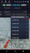
- Chart color coding and pinboards: Easily filter specific chart types and pin charts for quick access
- Interactive enroute charts: Click and search airports, waypoints, navaids, airways, controlled and restricted airspaces, FIRs/UIRs, holding patterns and more
- Flight plan import: Import flight plans from SimBrief and other external route calculator tools
For the ultimate experience we recommend subscribing to Navigraph Ultimate which ensures that you are always flying using the most recent charts and navdata used by all online pilots and air traffic controllers in the flight simulation community.
Navigraph Ultimate includes, in addition to worldwide charts access, updated navdata parsed into more than 120 different addon formats including aircraft like PMDG B737/747/748/777, Qualitywings B787, Flight Factor A320, IXEG 737 and many more. Navigraph Ultimate also includes regular updates to the navigation databases in flight simulators such as X-Plane 11.
Please note that:
- This product is for home flight simulation use only and must not be used for real world navigation
- This product is free to use in demo mode but requires a Navigraph account
- This product requires a Navigraph Charts or Navigraph Ultimate subscription for full access to all airport charts
Pro tips:
- We recommend that you install Navigraph Charts on your desktop too. All changes you make to Flights, Favorites and Pinboards are immediately reflected on your tablet
- With a current Navigraph Charts or Navigraph Ultimate subscription you can also access airport charts in the virtual Electronic Flight Bag (EFB) on the virtual flightdeck of many addon aircraft
Magst du Flugsimulation? Navigraph Charts ist die bevorzugte Karten-App in der Flugsimulations-Community und bietet die größte verfügbare Abdeckung von Jeppesen-Karten, die alle 28 Tage nach dem AIRAC-Zyklus aktualisiert wird.
Mit Navigraph Charts können Sie Flughafendiagramme von 6.800 Flughäfen auf der ganzen Welt suchen, anzeigen und organisieren. Sie können es mit FSX, Prepar3D oder X-Plane verbinden, um Ihre Position auf Karten zu zeichnen, oder es unabhängig verwenden, um Ihre Route zu planen.
Navigraph Charts enthält die folgenden Funktionen:
- Weltweite und aktuelle Jeppesen IFR-Karten: mehr als 6.800 Flughäfen abgedeckt (Navigraph-Abonnement erforderlich)
- Verschieben von Karten: Stellen Sie eine Verbindung zu X-Plane, FSX und Prepar3D her, um die Flugzeugposition des Simulators in Echtzeit auf den Karten anzuzeigen (erfordert Navigraph Simlink auf dem Simulatorcomputer).
- Nachtmodus: Dunkle Designversion der Karten bei schlechten Umgebungslichtbedingungen
- Routenberechnung: Berechnen Sie automatisch eine Route zwischen einem beliebigen Flughafenpaar direkt in der App
- Visuelle Übersichten zu SID und STAR: Zeigen Sie die auf der Streckenkarte überlagerten Flughafenverfahren an, um den Luftraum besser zu verstehen und die Flugplanung einfacher zu gestalten
- Flugorganisation: Zeigen Sie die Flugroute interaktiv auf der Streckenkarte an und sammeln Sie Karten für Abflug, Ziel und Alternativen an einem einzigen Ort
- Kartenüberlagerungen: Überlagern Sie SID-, STAR- und Anflugkarten auf der Streckenkarte, um Übergänge zwischen verschiedenen Flughüllen zu vereinfachen und das Situationsbewusstsein zu erhöhen
- Farbcodierung und Pinwände für Diagramme: Filtern Sie ganz einfach bestimmte Diagrammtypen und Pinwände für den schnellen Zugriff
- Interaktive Streckenkarten: Klicken und suchen Sie Flughäfen, Wegpunkte, Seezeichen, Atemwege, kontrollierte und eingeschränkte Lufträume, FIRs / UIRs, Wartemuster und mehr
- Flugplanimport: Importieren Sie Flugpläne aus SimBrief und anderen externen Routenberechnungstools
Für die ultimative Erfahrung empfehlen wir das Abonnieren von Navigraph Ultimate, um sicherzustellen, dass Sie immer mit den neuesten Karten und Navigationsdaten fliegen, die von allen Online-Piloten und Fluglotsen in der Flugsimulations-Community verwendet werden.
Navigraph Ultimate enthält neben dem weltweiten Kartenzugriff aktualisierte Navigationsdaten, die in mehr als 120 verschiedene Zusatzformate analysiert wurden, darunter Flugzeuge wie PMDG B737 / 747/748/777, Qualitywings B787, Flight Factor A320, IXEG 737 und viele mehr. Navigraph Ultimate enthält auch regelmäßige Aktualisierungen der Navigationsdatenbanken in Flugsimulatoren wie X-Plane 11.
Bitte beachte, dass:
- Dieses Produkt ist nur für die Heimflug-Simulation bestimmt und darf nicht für die Navigation in der realen Welt verwendet werden
- Für die Verwendung dieses Produkts im Demo-Modus ist ein Navigraph-Konto erforderlich
- Für dieses Produkt ist ein Navigraph Charts- oder Navigraph Ultimate-Abonnement erforderlich, um vollen Zugriff auf alle Flughafenkarten zu erhalten
Profi-Tipps:
- Wir empfehlen, dass Sie Navigraph Charts auch auf Ihrem Desktop installieren. Alle Änderungen, die Sie an Flügen, Favoriten und Merklisten vornehmen, werden sofort auf Ihrem Tablet angezeigt
- Mit einem aktuellen Navigraph Charts- oder Navigraph Ultimate-Abonnement können Sie auch im virtuellen Electronic Flight Bag (EFB) auf dem virtuellen Flugdeck vieler Zusatzflugzeuge auf Flughafenkarten zugreifen

Navigraph Charts – APK Informationen
APK Version: 7.0.3Paket: com.navigraph.chartsNeueste Version von Navigraph Charts
Weitere Versionen


Apps in derselben Kategorie
 4.284.464.073.783.37
Das könnte dir auch gefallen...


